|
powered by pitcom
|
 |
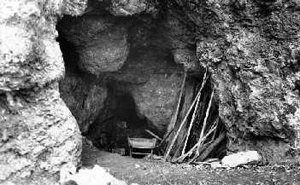
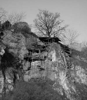
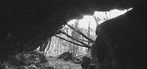
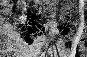
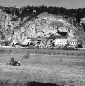
The paleolithic site of La Chaise-de-Vouthon (Charente) is composed of three cave and shelters and several inexplored cavity opening in a massif of Bajocian dolomitic limestone: Abri Bourgeois-Delaunay, Abri Suard, and Grotte Duport. The first one was discovered and excavated by Jean Fermond since 1850, but the abbés Bourgeois and Delaunay have described it only in 1865.
In 1870, Abbé Suard began to excavate a little crack situated near the precedently excavated cave and found a new shelter: Abri Suard.
It's only in the end of the 30's and principally afetr the war that Pierre David excavated the two shelter since 1963.
Abri Suard and Bourgeois-Delaunay were then excavated by André Debénath since 1967 to 1983. |
 |
 |
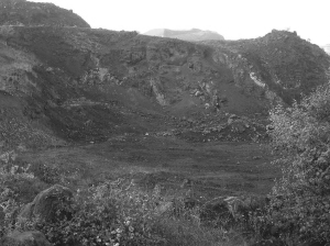
The quarry of Artenac (village of Saint Mary), provided several archaeological discoveries. Artenac is for the first time cited in 1959 in nomenclature archeologique, when a sepulchral cave, now destroyed, was open due to a mine explosion. The site yielded to Cl. Burnez a brilliant chalcolithic civilisation. He named it Artenacien.
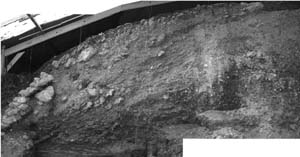
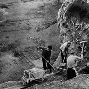
In 1972, Jean-François Tournepiche pointed out a new paleolithic site. In 1974, during rescue excavation, Bernard Vandermeersch collected an abundant Mousterian material. In 1982, the progressive destruction of the site required a new intervention. Excavations conducted by Jean-François Tournepiche showed the cavity was filled up 18 metres high. The cave showed just a narrow crack (5-6 meters) in which brecchias and clays deposits were accumulated.
The observation of the first fossiliferous level reveals the existence of Deninger bear den but also used by Panthera gombaszoegensis, Machairodont, and the Mosbach Wolf. These animals are all characteristic of the Mindel glaciation. The presence of human are just attested by some fragments of flint.
Little more higher in the sequence, a very rich level of brecchias and red clays are just over a stalagmitic horizon. Mosbach Horse bones are abundant and are associated with a little bit of Cervid bones. Accumulation of Herbivorous bones seems to be due to Wolf, Lion and Machairodont, frequent. But flints, flakes, tools and bifaces ask the question of the role of humans at this period in the cave (end of the Mindel, or Mindel-Riss).
The site is now almost destroyed but gives a lot of documentation on the time of the first human "peopling" in Poitou-Charente just as its environment. But it doesn't permit to know who were the first inhabitants either how they lived.
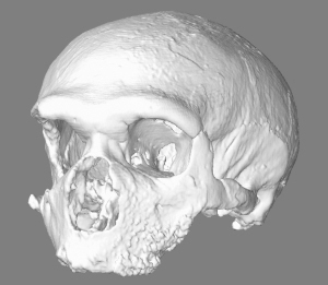
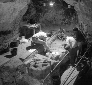
Until 1993 the excavation of the superior sequence is conducted by Anne Delagne. If levels at the base contain acheulean bifaces in disturbed position, the rest of the sequence enclose rich Mousterian industry. This is in this archaeological context of Mousterian ("Ferrassie type") dated from the first part of the late Würm that human remains were discovered : a maxillar and a frontal belonging to Neanderthal. |
The Limestone Bedrock was built during the Devon (380 mio. BP). A 18m broad, 12m high and about 90m deep cave builts the so-called Balver Höhle (Balve Cave). Two lateral corridors are named after the early researcher Rudolf Vorchow and von Dechen.
First excavations were realised by the 'Königliche Bergamt Siegen' in 1843. In that time the first fossils have been found, like tusks and molars from prehistoric elephants. Within the next decades the cave was excavated completly and about 53.000 lithic and faunal remains have been found. They are attributed to the Upper Palaeolithic (Magdalenian) and the MIddle Palaeolithic (Mousterian).
Because of this enormous amount of anthropological remains the Balver Höhle is one of the most important prehistoric sites in Germany. Most of the lithic material cann be attributed as Mousterian and Micoquian Industries, about 80.000 years old.
The Assemblages of the Balve cave are separated into:
- Late Acheulian: Balve l
- Micoquian:Balve II, III und lVa
- Late Mousterian: Balve IVb
|
 |
 |
At first the Bockstein has been excavated in 1879, 1881 and 1884-1885 by Ludwig Bürger (1844-1898). He worked in a younger entrance that has opened after the original cave has partly collapsed. This excavation revealed Mesolithic finds and a burial of a woman and its child. The age of the burial has been negated by the scientists at the end of the 19th. Century. Recent studies have proved the Mesolithic age of the skeleton of the child (Wehrberger 2000), which is around 7400 BP years old. The remains of the woman are lost.
All embracing excavations were realised by Robert Wetzel. He excavated the Bockstein-Törle, which was the former entace of the Bockstein. Between 1932 and 1935 he excacated the Bocksteinschmiede and the Bocksteinloch, where Wetzel revealed a stratigraphy from the upper Palaeolithic and the very import layer Bockstein III with bifacial tools, that were determined as Micoquian. To approve the stratigraphy, Wetzel resumed the field work and excavated the slope from 1953 to 1956. The results of this excavations were published post mortem in 1969. |
The site was already known since 1840. It was re-discovered in May 1963 during road works, when the rock has partly been blown up. First trenches were excavated in october and november 1965 by J. Kulick. Two excavation areas seperates the site Buhlen into an upper site (excavation) at the top of the hill and a lower site (excavation), which is in fact the slope of the hill interlaced with the Netze River bank.
The upper site is structured in two stages or steps of rocks. On the top there was a little cave, that has been collapsed in different phases. Occupation levels can be found around in the cave. The upper site has been excavated regulary from 1966 to 1969 by G. Bosinski.
The lower site contains older and younger sediments than the stratigraphy abouve. The lower site was excavated with a test trench in 1966 and 1967 by G. Bosinski, and later between 1980 and 1986 by L. Fiedler (Landesamt für Bodendenkmalpflege Marburg). Recently the upper site has been analysed by O. Jöris. The lower site is still not published completely. |
 |
 |
During a school excursion in 1936 pupils found a worked mammoth rib in the rhine gravels and gave it to their teacher Mr. Kaiser. He braught the rib to the Niederrheinisches Museum der Stadt Duisburg the 28.5.1957. Unfortunately there are no further informations about the location or find circumstances. |
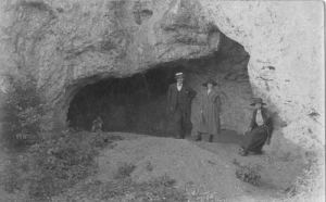
The site is known since the end of the XIXth century. The first known excavator was a teacher, M. Plaire. Then the cave was excavated by M. Louis Durousseau-Dugontier (1902-1910). He found broken pottery, Aurigniacian and Châtelperronien as well as a cranial vault and some human remains.
More systematic excavation was performed by M. Vallade (1913-1914).
So, some excavators worked in Fontéchevade, but in 1937, Germaine Henri-Martin began methodic excavations during 20 years.
Fontéchevade was also excavated by André Debénath between 1990 and 1994, and new excavation was undertaken by the University of Pennsylvania, Bishop Museum, and the Université de Perpignan till 1998. |
 |
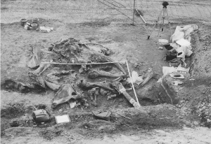 |
During mining activities in the opencast Lignite Mine "Gröbern", north-east from Bitterfeld, in June 1987 a nearly complete skeleton of a long tusk elephant (Elephas antiquus) have been found. In serveral weeks the complete skeleton was excavated. Between the bones of the elephant, about 27 stone artefacts and a fragment of a cervide bone was found. These and the fact that the bone weren't in their anatomical position, leads to the interpretation that Gröbern was a killing and butching site.
The situation was found in 6 m depth, at the border of an ancient lake. The deposits in which the skeleton was found, are dated to the Eemian Interglacial Warm Period. The age is therefore estimated with about 125.000 BP.
In September 1987 a second elephant skeleton was found. This young individual (pup) doesn't show any evidence of human influence. It seems that is has drowned in the lake. |
| Große Grotte lies 76m above the valley floor near Blaubeuren. Excavations at Große Grotte were carried out by Gustav Riek in the 1960s, who distinguished 12 Middle Palaeolithic layers (II–XIII). The artefacts and fauna were published in a monograph by Eberhard Wagner (1983), but during an inventory in the Natural History Museum in Stuttgart new faunal material was found and all faunal remains were reanalysed by Jaco Weinstock (1999). Layer II, the richest in faunal and lithic materials, belongs to a late Mousterian with bifacial points. |
 |
 |
Monte Circeo is a limestone massif, 541m high and covering 32km. Its southern edge is bordered by the sea. The cave is on the easternmost spur of Monte Circeo, standing near the village San Felice Circeo. |
The site is located in between the caves Vogelherd and Bockstein, down in the valley on the right shore of the Lone-river. The Hohlenstein is a cave system, containing two caves: Bärenhöhle in the western part, and Stadel in the western part, in between lays the abri Kleine Scheuer.
The site was discovered 1862 by Oscar Fraas.
 |
The site was discovered in 1956 by the palaeontologist Fl. Heller, who searched for faunal remains of the Early and Middle Pleistocene. He continued his research at Hunas until 1964. In 1986 the local excavation leader was Wolfgang Weissmüller. From 1984 to 1986 the excavations were led by Brigitte Kaulich. A Neanderthal tooth has been discovered during cleaning the profile. The stratigraphical position of the tooth is not clear. According to Groiß and Kaulich (1987) it either comes from the layers G2, G3 or H. |
The site was found during the exhaustion of an open lignite (brown coal) mine in the 1960's. It is located in northern Harz foreland, on the north border of a former lake, the Ascherslebener Lake. The lake was approx. 1 km far to the south of the village Königsaue. The shore of the lake was drained in the 18th century. From 1918 to 1977 the area around Königsaue was distroyed because of an opencast lignite mine.
Königsaue was dicovered by D. Mania and V. Toepfer, during geological field work. Because of the coal mine a ordinary excavation was not possible, but the site have been observed and recorded between 1963 and 1964, so that a quiet detailled documentation was possible. Approx. 5000 m2 have been surveyed and 64 trenches were realised to analyse the shore of the former lake. The results were published in 1973 (Mania and Toepfer 1973).
Three find horions from the Middle Palaeolithic (Micoquo-Pradnikian) have been documented. Approx. 6000 pieces were excavated, including bifacial worked knives (Keilmesser), handaxes of the La Micoque Type, unretouched blades and small debitage. The Layer Königsaue A is dominated by bifacial tools, while Königsaue B prepared cores are typical. In Königsaue C bifacial tools are again dominant.
The horizons were located on the flat northern shore terrace of the lake. To the north the small hill "Großer Bruchsberg" arose, to the east there was an alluvial fan. This situation seemed to be an ideal settlement situation for the early hunter-gatheres.
The most famous finds from this site are two pieces of birch-pitch, that might be used as hafting material fro a composite tool. They are the oldest evidence for the use of chemical processes (dry destillation).
The site is interpretated as as a sesonal hunting camp. |
 |
 |
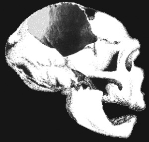
THE WORLD's LARGEST NEANDERTHAL FINDING SITE
In the year 1899, the fossil remnants of the Homo sapiens neanderthalensis species were found at the excavation site located at the Hušnjak hill in Krapina.
During a six-year research at the site, led, for the time, by highly expert Dragutin Gorjanović-Kramberger, a total of 876 single fossil Neanderthal fossil remains were found, placing Krapina in the world's scientific heritage as the world's richest Neanderthal finding site. |
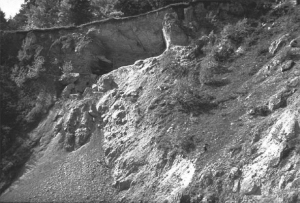
The presence of archeological material was first recognized by G. Chauvet and M. Vergnaud in 1872. They found mousterian industries in a cave at the top of the cliff and few remains along the talus. The real significance of the site was finally discovered in 1881, when the construction of a road grazed the cultural strata. Excavations have been led by Dr L. Henri-Martin (1905-1936), his daughter Germaine Henri-Martin (1953-1972) and most recently by A. Debénath and A. Jelinek (1985-1994). The site of La Quina includes a series of deposits that extended for about 1000 m along a cliff which bounds the valley of the Voultron river. Two areas have been distinguished :
- the Station Amont at the middle to northeastern part of the site which yielded mousterian layers and human remains attributed to the Neandertals.
- the Station Aval at the southwest end which yielded a sequence of Mousterian, Chatelperronian and Aurignacian.
|
 |
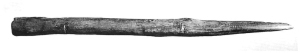 |
The 17. 03. 1948 the retired director of a secondary school , A. Rosenbrock, found in a clay or marl pit a skeleton of an Elephant. The site is situated approx. 10 km south-east from Verden at the Aller river, close to Lehringen. It was laid open by dredger activities in a merl pit. During a "non-professional" excavation in the next days, Rosenbrock could excavate the nearly complete skeleton of an forest elephant (Elephas antiquus), together with serveral stone artefacts (mostly unretouched flakes). The most spectecluar find was a wooden lance. Unfortunately, the circumstances of the excavation are not ducumented very well, and no photo was taken during the field work.
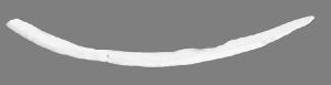
The site of Lehringen was the first evidence for the acitve hunting of prehistoric man with wooden spears and lances. |
 |
The story of Marillac began in 1898 when E. Vincent notified the discovery of the place. He wrote that the site is not interesting for science. But scientists like P. David, L. Ragout et A. Balout waited 1933 and 1939 to be interested by the site while it was worked by M. Richeboeuf. He collected fossil bones (Hyaena, Bovids, Equus, Canis lupus, Vulpes sp. ...)and lithic material. In 1934, a fragment of a neandertal mandible was discovered.
It was only in the years 1967-1980 that Bernard Vandermeersch organized the first real archaeological excavations in Marillac. The stratigraphy was established, identifying more than 12 geological layers related to one main sedimentological process. important fauna and lithic material was collected. Excavations yielded also numerous hominin remains like a posterior part of a neandertal mature occipital with cut marks and a partial upper dentition of a young specimen. |
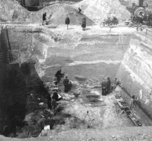
In the Neander Valley (the Neandertal in German in the summer of 1856 quarrymen discovered the fossilised remains of a skeleton - which has since achieved world-wide fame.
New excavations 1997 led to "the discovery that the base of the south valley wall was left intact, and cave sediments were located adjacent to this remnant. Excavation of these deposits resulted in the recovery of Paleolithic artifacts, Pleistocene faunal remains, and some 24 fragments of human bone from the clay sediments on the valley side of the remnant. That these must at least in part represent remains from the Kleine Feldhofer Grotte was confirmed when a small piece of human bone (NN 13) was found to fit exactly onto the lateral side of the left lateral femoral condyle of Neandertal 1."
In 2000, the excavations of 1997 were continued, " and a much larger series of fauna, artifacts, and human skeletal fragments was recovered. Two cranial fragments from these excavations were found to fit onto the original Neandertal 1 calotte." |
 |
 |
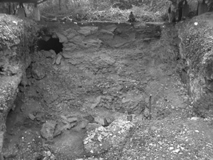
A Former fossil lake, filled with deposits from the last interglacial sequence. Recovered during mining activities of the opencast lignite mine Neumark-Nord in the 1980ies. It was excavated from 1986 to 2004 in serveral excavation campaigns.
After the recent excavations from the Landesamt für Denkmalpflege und Archäologie Sachsen-Anhalt (ArchLSA), actually three fossil lake basins are known:
- Neumark-Nord 1 (NN1) is the "classic" site, that was excavatied by an interdisciplinary research group around D. Mania from 1986 to 1996. It has revealed important features concerning hunting activities of fossil man. In 2004 the ArchLSA opened a small trench to verify the stratigraphical sequence. Neumark-Nord 1, General Stratigraphy
The basin NN1 is dated to an Intra-Saalian Interglacial, between the Drenthe and Warthe glacial Period.
- Neumark-Nord 2 (NN2) was discovered 1997 during renaturation work at the former opencast lignite mine of Neumark-Nord. This former lake basin contains Eemian to Early Weichelian deposits. It includes also sediments from the Warthe glacial period. Neumark-Nord 2, General Stratigraphy
- Neumark-Nord 3 (NN3) the third small lake basin that contains sediments from a warm period of the Holstein Complex. It was trenched from 2003 to 2005 by the ArchLSA
- Neumark-Nord 4 (NN4) is an artefact assemblage, that was found in a gravel layer on the top of the deposits of the lake basin NN2. Serveral artefacts were collected from this gravel in spring 2004.
|
The site has been discovered 1985 by Karl-Heinz and Andreas Urmersbach, who found animal bones and stone artefacts in the loess-infill of a crater (“Wannenvulkan”). The first excavations took place 1986 by Antje Justus, and revealed few middle palaeolithic stone artefacts (silex, quartz, and quarzite) and abundant animal remains (rhinoceros, elefant, reindeer, saiga-antelope, deer, lion, and brown-bear). The assemblage proves repeated, longer-term human presence at the site. Several excavation-campaigns followed Ochtendung 1986-1990 (Justus 2000).
In another mould nearby, a second site was discovered and excavated in Ochtendung 1993 (von Berg 2003). It revealed an artificial, circular stone setting with animal bone fragments and few stone artefacts inside. Possibly it is a dwelling structure of a short-term occupation. About a distance of 200 m from these two sites, in 1997, three fragments of a calotte of a Neanderthal Ochtendung 1, in association with three stone artefacts were found by Axel von Berg. The finds were located in a package of loess-sediments from the original infill of a crater, which was unfortunately not in situ, but recently displaced by industrial lava mining activities.
The archaeological remains can be stratigraphically and absolutely chronologically placed within the early glacial phase of the second last glaciation, the Saale. (von Berg, Flohr, Protsch von Zieten 2004) |
 |
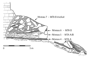 |
This site is one of the first prehistoric site known in France. A lots of digger have worked on it but it is François Bordes who established the last and actual stratigraphy. Four main layer have been distinguished:
- Layer 4 wish is attributed to Mousterian of Acheulean Tradition type A. It is a very thik layer specially rich in burned bones.
- Layer 5 wish seems to result from a contamination from Layer 4 and 6 (Soressi, 2002) and is quite poor in material.
- Layer 6 and 7 are attributed to the Mousterian of Acheulean Tradition type B.
|
Small cave on the top a hill, under a medival castle. The cave is called: Ilsenhöhle. It was excavated preliminar between 1926 and 1931 by Dietrich von Breitenburg. Regular excavations were realised between 1932 and 1938 by Werner M. Hülle, from the former Landesanstalt für Vorgeschichte Halle/Saale.
During the excavations the forecourt and the cave were excvavated completely. Altogether about 250 m 2 have been excavated.
The excavations of Werner Hülle were summarised by him shortly before his death ans published in 1977.
The cave Ilsenhöhle is subdivided in a vestibule, which is 10 to 15 width and 8 to 10 high. Two deeper rooms, from 10 m length each, resume from this vestibule. Both rooms are at their beginning ca. 3 m broad, but are getting smaller quite quickly. |
 |
 |
The site is located in the “Niederrheinische Bucht” in between the rivers Rhine and Meuse, in the southeast of the town Mönchengladbach-Rheindahlen. The brickyard lies 76 m NN (above sea level).
“The site of Rheindahlen is located in the Dreesen brickyard near Mönchengladbach, close to the northern border of the loess belt.
Several archaeological layers have been reported and partially excavated in different campaigns since the 1960ies.
The stratigraphical layers with palaeolithic remains are A1 (final palaeolithic), A2-A3 and B1-B5 (middle palaeolithic) and C1 (early palaeolithic).
The first palaeolithic artefact has been discovered 1915 by the teacher Prof. H. Brockmeier. Later finds have been reported by the geologists E. Kahrs. Kahrs discovered 1930 the site “Rheindahlen Ostecke”. This was investigated 1949 by the archaeologist K.J. Narr on behalf of the Rheinisches Landesmuseum Bonn. (Narr 1951)
In the following decades the proprietor of the brickyard, Mr. Dreesen and his workers and later the farmer Mennen continued collecting artefacts.
In 1964, Gerhard Bosinski started the archaeological investigations in the “Ostecke” with 21 sondages with the aim to verify the stratigraphical position of Kahns archaeological finds. At the same time S.K. Aurora discovered the site “Westwandfundplatz” (B1) which was cut by the dredger. With the progression of the loess-mining, this site was excavated in six campaigns, each of them lastig one week, in 1964 and 1965.
In September and October 1965 G. Bosinski excavated an area of 50m² in the “Ostecke” (B3). In the following years, the farmer Mennen kept collecting artefacts on his ground.
1973-75 Hartmut Thieme continued excavating in B3. He investigated 90m² in three campaigns of two months. He also investigated B1 in between 1967 and 1980.
1980 he detected an artefact scattering of about 50 m² extension.
1984-85 J. Thissen excavated 60m² in the „Westwandfundschicht“.
1995-1997 new excavations in B1 „Westwand“ by Schmitz and Thissen. |
| This collapsed cave was discovered by Roger Constant, the proprietor of the place. He excavated until 1957 when a partial skeleton of a Neanderthal was encountered in the Mousterain deposits. E. Bonifay undertaken the excavations and clarified the stratigraphy and the nature of contained archaeological remains. |
 |
 |
The main cavity (measuring 15x5m) was excavated by earlier researchers who had completely destroyed the archaeological deposits without realising exactly what they contained. In 1985, soundings revealed the presence of a little diverticulum rich in bones. This diverticulum, containing a significant faunal accumulation, is 10 meters long and no more than 1 meter in diameter. Taphonomy studies identify hyaena as the agent of this accumulation. This diverticulum continue by a first room, a second passageway and a second room. |
| Roc de Marsal (Dordogne, France) is a Middle Paleolithic (Mousterian) cave near Les Eyzies. It was excavated by Jean Lafille until his death in 1971. In addition to a rich sequence of stone and bone assemblages, Lafille found the fossilized remains of a Neandertal infant that appeared to have been intentionally buried. The site, like many from this region, was never well published. |
 |
 |
On the terrain of a sewage treatment plant the first excavation took place in 1952 under the directory of Alfred Tode. Thanks to him the interdiscilinary research in Salzgitter-Lebenstedt was ahead of the times and his documentation is still up-to-date. 25 years later it was Klaus Grote in 1977 who directed the second and last excavation in Salzgitter-Lebenstedt. Between the underlying package of gravels and the solifluction loess deposits on top of the stratigraphy several sediments with prehistoric remains (lithic, fauna, macro remains, mushroom and pollen) were found. Additionatlly human remains and bone-tools are highlights of the site. |
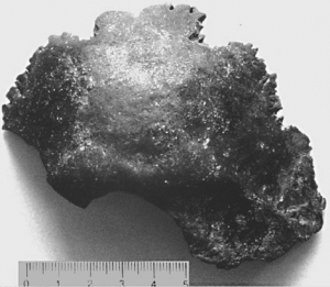
Tree hominid skull fragments were found in 1997 and 1999 by two non professional archaeologists Ortrud and Karl-Heinz Frangenberg. They were discovered in coarse-grained deposits that were dug in a gravel pit on the Leine river flats in the vincinity of the City of Sarstedt. The geological position of the lower terrasse is not clear. They have accumulated during a undetermined warm period - possibly Brörup or Odderrade - during the Weichsel glaciation.
The skull fragments are determined as Homo Neanderthalensis by Carnetzki et al. (2001). Several artefacts, that were found with the hominid remians assign the assemblage to the Middle Palaeolithic, and show typologically a relation to the Micoquian (Keilmessergruppen). |
 |
 |
The site has been excavated during the years 1964-1977 and 1981 by the Institut für Ur- und Frühgeschichte, Universität Nürnberg-Erlangen. Overall, 50 qm within the cave as well as in front of the cave have been excavated. By this, Medieval, Mesolithic, Upper Palaeolithic as well as several Middle Palaeolithic layers have been revealed.
The site yielded about 100 000 artefacts of the Middle and Upper Palaeolithic, the remains of 3 Neanderthals as well as abundant faunal material. It has also provided the longest Middle Palaeolithic Sequence of the last glacial in western Central Europe.
The Sesselfelsgrotte yielded a sequence of the last glacial consisting of 22 archaeological units of the Upper Middle Palaeolithic (layers 1-West to E3) and 6 archaeological units of the Upper Palaeolithic (some Gravettien finds from layer E3 and five inventories from layer C) |
| Site paléolithique parmi les plus importants d'Europe, la grotte fut fouillée à de nombreuses reprises. Mais c'est en 1886 que l'on y fit une découverte qui représente de nos jours encore un épisode capital de l'histoire des sciences. En effet, les fouilles menées à Spy par une équipe liégeoise composée d'un archéologue (Marcel De Puydt), d'un géologue (Max Lohest) et d'un paléontologue (Julien Fraipont) permirent de faire admettre définitivement par la communauté internationale l'existence d'un type humain plus archaïque que l'homme moderne : l'Homme de Neandertal |
 |
 |
The Vogelherd cave is located near Stetten in southwestern Germany.
The cave lies in a 200 m high hilltop of the Swabian (white) Jura, in the Lone Valley 18 m above the riverbed. The three galleries of the cave join in the centre and open to the North, South-East and South-West (Y-shaped ground plan).
In 1931, when the cave was discovered by Hermann Mohn, who found silex chips at a badger's burrow, the cave was almost completely filled by sediments.
Gustav Riek "directed excavations at Vogelherd (…) in the summer and autumn of 1931 Vogelherd 1931. Over a period of three months the excavation team removed about 300m³ of pleistocene sediments from the cave and recovered artefacts from four Middle Palaeolithic layers and four Upper Palaeolithic layers. Riek published 12 stratigraphic profiles and detailed descriptions of the sediments from the cave." (Conard, Grootes, Smith 2004: 198)
A later excavation campaign 1978 Vogelherd 1978 by Eberhard Wagner at the entrance could not result to more information. |
3 km to the north-west from Warendorf (D) a gravel pit (Warendorfer Hartsteinwerke) conveys gravel and sand from about 16 m depth. J. Gora collected the skull fragment together with serveral stone artefacts in 1995 from the surface of the mining dump. The object was determined as a fragment of a Homo Neandertahlensis in 1997, when an inventory of archaeological sites was raised by the "Amt für Bodendenkmalpflege, Westfalen-Lippe".
The skull fragment from Warendorf is the northernmost fossil remain of the Neandertal Man. |
 |
 |
Since the beginning of this century the travertine quarries of Weimar-Ehringsdorf belong to the classical Middle European sites of research for Pleistocene archaeology. The site is situated in the middle of the Thuringian basin in a rift valley named Ilmtalgraben. Travertine was caused by springs that drained through the karst (Muschelkalk). The spring water was rather warm, i.e. 8 to 12 degrees centigrade, so the places at the side of the springs were attractive both for man and for the Pleistocene animals. |
|
|